Anza-Borrego North: Lute Fault Scarp
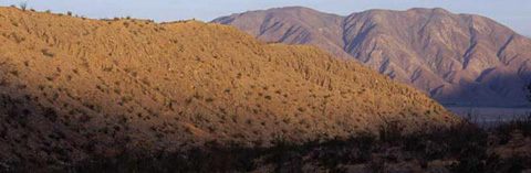
Lute Fault Scarp from the North with Coyote Mountain in the Distance
An easy walk from County Road S-22, the Lute Fault Escarpment is a pile of hard-packed rock and sand more than two miles long. It is the longest and (from the north side as pictured above) tallest of a number of fault scarps to the southeast along the Clark earthquake fault
Over millions of years, storms have eroded the sides of the Santa Rosa Mountains causing rocks and sand to pile up on the fault. The earth has moved as earthquakes have taken place, and the sand piles have been hardened and stretched into escarpments, or scarps.
If you study the habits of wildflowers and you visit in wildflower season, you might find it interesting to compare the flowers you see on the scarp with the flowers you see in the mountains.
Getting to Lute Fault Scarp. Drive 10 miles east of Christmas Circle in Borrego Springs on County Road S-22 and park at Call Box S22-319.
There is no path to the Lute Fault Scarp. It is the large ridge on your left as you walk toward the mountains. When you get to it, you should find an easy trail of a few steps to put you on top.
To see other fault scarps, return to Call Box S22-319 and look south along the unpaved Thimble Trail or west along the unpaved Truckhaven Trail.
© Anza-Borrego Desert Natural History Association. All Rights Reserved.