|

Join Our Email List
For Regular Updates On
ABDNHA Programs
And More
Introduction
When people hear the term geology, they think of rocks. In one sense
this is fitting, because rocks are indeed the raw material geologists use to
extract information about the Earth. In another sense, however, equating
geology with rocks (and leaving it at that) misses something critical. Beyond
the rocks themselves, the science of geology is concerned with the two-fold task
of understanding Earth’s present and reconstructing its past. The Anza-Borrego
Desert offers geologists limitless opportunities in this regard.
|
|
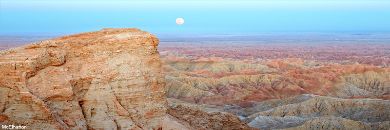
Photo: Full moon rising
over Fonts Point and the Borrego Badlands. Fonts point is capped by sand
and gravel deposits laid down by ancient streams within the last 600,000 years.
Stretching out beyond Fonts Point, the Borrego Badlands consist of alluvial fan,
lake, local stream, and ancestral Colorado River deposits up to 4 million years
old.
Anza-Borrego Geology -
by Don Barrie
The geology of Anza-Borrego is a long and complicated story. Before
we move forward, you need to understand the basics of plate tectonics
if you are unfamiliar with this term. View
Plate Tectonics Details |
Hide
Details.
PLATE TECTONICS
Developed in the 1960s, the theory of plate tectonics posits that
Earth’s outer shell is broken up into a series of brittle slabs of rock that
slide around atop a mobile, plastic interior. These brittle slabs, called
plates, move on average at about the rate your fingernails grow, although
occasionally catastrophic plate motion occurs during strong earthquakes.
Where two plates meet, plate boundaries develop, and this is
where the action is, geologically speaking. Plate boundary processes include
earthquakes, volcanism, mountain building, the growth of continents, and the
opening and closing of ocean basins. Think of plate tectonic theory not simply
as another aspect of geology, but as the guiding model, or paradigm, which
allows geologists to make sense of Earth’s geologic features and processes.
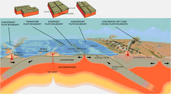
The essence of plate tectonic theory is simplicity itself: where
two plates separate, a divergent plate boundary develops. Continents are torn
asunder and new ocean basins created at divergent plate boundaries. Where two
plates move toward each other, a convergent plate boundary develops. Plate
convergence creates mountain ranges and explosive volcanoes. Finally, where two
plates move sideways past each other, a transform plate boundary develops,
deforming the landscape in complex ways. As discussed below, divergent,
convergent, and transform plate boundary processes have sculpted the geology of
Anza-Borrego over hundreds of millions of years of geologic time.
PLATE TECTONIC HISTORY OF THE ANZA-BORREGO REGION
The plate tectonic story of Anza-Borrego opens around 450 million years ago—the
approximate age of Anza-Borrego’s oldest rocks. During this period in geologic
history, the western edge of North America lay underwater, beneath an ancient
ocean, relatively far from a plate boundary. Geologists refer to such regions as
passive continental margins. Although plate boundaries don’t occur at passive
margins, such margins are created by plate divergence. As a single continent is
torn apart, passive continental margins develop on each side of the tear as the
two continental fragments migrate away from the tear in opposite directions,
with the tear itself representing the divergent plate boundary. A modern example
of this process occurs along the margins of the Atlantic Ocean basin. As North
America and Europe drift apart, passive continental margins have developed along
North America’s East and Gulf coasts and Europe’s west coast, with a divergent
plate boundary, the mid-Atlantic ridge, in between.
Long before the origin of the Atlantic Ocean basin, thick sediment deposits
accumulated along a passive continental margin bordering the Pacific Ocean basin
and North America to the west—testament to the break-up of an older
supercontinent. These deposits eventually became Anza-Borrego’s oldest rocks.
With deep burial and cementation, these ancient sediment layers hardened into
marine sedimentary rocks, including sandstone, mudstone, and limestone. Later,
these marine sedimentary rocks would be squeezed and baked by intruding magma
(molten rock in Earth’s interior) and transformed by pressure and heat into
metamorphic rock. Limestone transformed into marble, sandstone into quartzite,
and mudstone into layered schist and banded gneiss--all metamorphic rocks
exposed in Anza-Borrego’s prominent mountain ranges, including Coyote Mountain
as well as the Santa Rosa, Vallecito, and San Ysidro Mountains.
|
 |
Beginning around 170 million years ago, passive
continental margin sedimentation in the region that is now southern California
gave way to a process called plate subduction.
Near the western edge of North America, a slab of sea floor (i.e., an
oceanic plate) slid eastward, underneath the western edge of the continent,
creating a type of convergent plate boundary called a subduction zone.
As the descending slab sank into Earth’s interior, it
partially melted, producing molten rock (magma) that rose buoyantly upward
along the edge of North America.
Most of this molten rock cooled and crystallized at depths of several miles
beneath Earth’s surface, producing the region’s oldest granitic rock--rock
that would only much later become exposed at Earth’s surface during later
mountain building events |
|
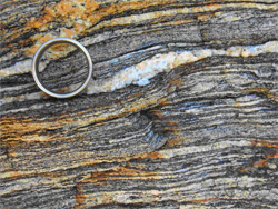
Banded metamorphic rock
(gneiss), Box Canyon (wedding ring for scale). |
|
Although little is known about this event, it is
preserved in discontinuous rock exposures west of the Anza-Borrego region,
in the Laguna Mountains along Sunrise Highway |
 |
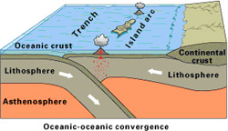
Around 130 million years ago, a chain of offshore islands called an island arc
developed roughly parallel to the western edge of the North American continent
in response to continued plate subduction.
These ancient islands hosted towering volcanoes similar to modern-day Mt.
St. Helens. Also like Mt. St. Helens, these ancient volcanoes occasionally
erupted violently and explosively. Beneath the island volcanoes, vast
volumes of magma were produced in Earth’s interior over the next several
tens of millions of years. |
|
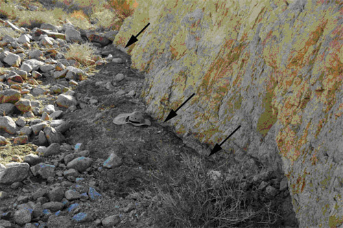
Detachment fault ( shown by arrows) Narrows Earth Trial |
Known collectively as the Western
Peninsular Ranges Batholith (Western PRB), this collection of igneous rock
bodies represents the cooled, crystallized remains of ancient magma chambers
that once fed an overlying island arc. Western PRB rocks range in age from
approximately 130 to 105 million years old and form the backbone of the Cuyamaca
and Laguna Mountains west of Anza-Borrego. Various varieties of granitic rock
were produced during emplacement of the Western PRB, including granite, a
light-colored igneous rock with a salt-and-pepper appearance, dark-colored
gabbro, and gray to white tonalite. To geologists, these various varieties of
granitic rock are evidence of ancient plate subduction.
 |
By
approximately 110 million years ago, the Western PRB island arc had migrated
northward, eventually colliding with the western edge of North America,
producing what geologists call a suture zone. Geologists consider the
Western PRB somewhat “exotic” in the sense that it formed in one place
(i.e., offshore) and later migrated northward to become part of North
America. Remnants of the suture zone that developed between the Western PRB
rocks and the edge of ancient North America are today nicely preserved along
Sunrise Highway in the Laguna Mountains west of Anza-Borrego |
|
Island Arc (courtesy USGS). |
|
|
|
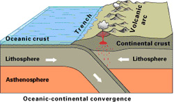
Continental
Volcanic Arc
(courtesy USGS). |
In contrast to the
island arc rocks of the Western PRB, which formed offshore, most of the
granitic rocks in Anza-Borrego formed beneath a continental volcanic arc
along the western edge of North America. These eastern rocks are known
collectively as the Eastern Peninsular Ranges Batholith (Eastern PRB).
Non-exotic Eastern PRB rocks (which formed in place) consist of various
varieties of granitic rock, including granite, granodiorite, and tonalite,
and like Western PRB rocks represent solidified magma chambers. |
|
Eastern PRB rocks are typically younger than
Western PRB rocks and range in age from 93 to 98 million years old.
Light-colored granitic rocks of the Eastern PRB are exposed in many of the
mountain ranges along the western side of Anza-Borrego, including the Fish
Creek, Vallecito, San Ysidro, Tierra Blanca, and Jacumba Mountains.
Plate tectonic theory shapes our understanding
of the relationship between older, Western PRB rocks exposed west of
Anza-Borrego and younger, Eastern PRB rocks exposed within the Park. Before
about 105 million years ago, the oceanic plate that had been subducting
eastward, beneath western North America was descending at a fairly steep
angle. However, after 105 million years ago, the angle of subduction became
flatter, shutting off magma production in the Western PRB and shifting it
eastward, to the Eastern PRB.
Magma production
ceased completely in the Anza-Borrego region by around 70 million years ago,
and the forces of running water and gravity began to dominate. Rocks of the
Eastern and Western PRB were deeply eroded to produce a series of plains and
low, rolling hills. During this period, several vertical miles of PRB rock
were removed via erosion, exposing rocks at Earth’s surface that had never
seen the light of day. Ancient streams carried the eroded remnants of older
PRB rocks westward, depositing thick sequences of layered sedimentary rock
along the continental margin.
EARTHQUAKE FAULTS AND
SEISMIC ACTIVITY
A major plate tectonic reorganization occurred in southern California around
30 million years ago. At this point in geologic time, convergent plate
motion (i.e., subduction) finally ceased altogether, and a complex plate
boundary began to develop as a result of both transform and divergent plate
tectonic motions. Sideways (transform) motion occurred along numerous cracks
in Earth’s crust called faults, culminating the development of Southern
California’s major fault zones, including the Elsinore, San Jacinto, and San
Andreas Fault Zones, within the last few million years. All of these faults
actually consist of numerous, closely spaced groups of faults, which is why
they’re more accurately called fault zones.
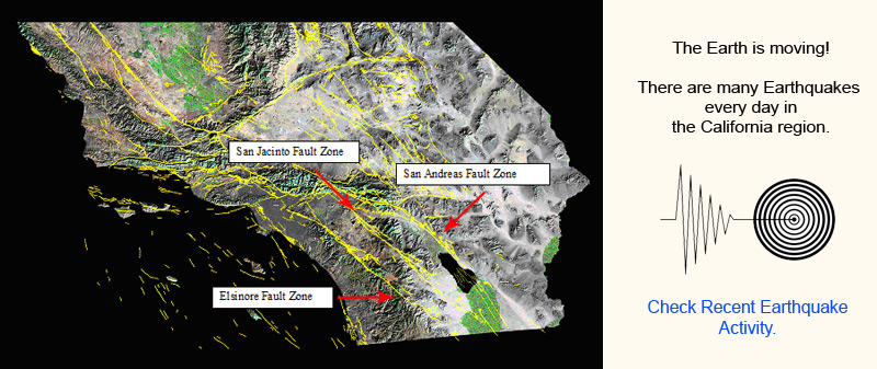 The Elsinore, San Jacinto, and San Andreas Fault Zones get all the press because they’re seismogenic—a fancy way of saying they’re capable of generating big earthquakes. All of these faults, called strike-slip faults by geologists, are steeply inclined, nearly vertical structures, and the motion across them is sideways and to the right. Here’s a way to picture this: stand on the west side of a strike-slip fault like the San Andreas, facing the fault, looking east. During the next big earthquake, the land on the far side of the fault will appear to move horizontally toward your right hand (i.e., toward the southeast).
The Anza-Borrego region is roughly bordered by the Elsinore Fault Zone to the west and the San Jacinto Fault Zone to the east. East of Anza-Borrego and immediately east of the Salton Sea, the mighty San Andreas Fault Zone forms the boundary between the Pacific and the North American plates. Although the San Andreas Fault Zone marks the actual boundary between these two plates, in a broader sense, the plate boundary is “mushy”—that is, it consists of numerous fault zones, including those comprising not only the San Andreas Fault Zone but also the Elsinore and San Jacinto Fault Zones to the west. The Anza-Borrego region is caught up in the wide “mush zone” between two of Earth’s major tectonic plates. No wonder this region experiences numerous earthquakes!
Even as strike-slip faulting, characterized by sideways motion, has occurred along the Elsinore, San Jacinto, and San Andreas Fault Zones, the Earth’s crust in the Anza-Borrego region has also undergone profound stretching within the last few million years. Although geologists debate the exact timing of this event, it’s clear what happened. The Earth’s crust began to stretch, and Baja California eventually tore away from mainland Mexico along a series of divergent plate boundary segments, creating both the Gulf of California and its northward extension, the Salton Trough--an elongate, narrow lowland that stretches northward from the Imperial Valley to Palm Springs. Currently, the bottom of the Salton Trough is occupied by California’s largest lake (in terms of surface area), the Salton Sea.
Crustal stretching produced its own style of faulting—a series of slightly curved to almost flat detachment faults that allowed large rock masses to break away from the mountains on the western side of the Salton Trough. Once mobilized, these gigantic blocks slowly slid eastward and downward into the widening chasm of the Salton Trough. Detachment faults can be found today within most of Anza-Borrego’s western mountain ranges. East of Anza-Borrego, out in the middle of the Salton Trough, the Earth’s crust has been so dramatically stretched and thinned that molten rock from Earth’s interior has been able to migrate to Earth’s surface. The Salton Buttes, which occur along the southeastern shore of the Salton Sea, consist of a series of lava domes no more than a few thousand years old. In addition, crustal extension has allowed subterranean heat from Earth’s interior to migrate close to the surface, supplying the energy source for numerous geothermal power plants in the Imperial Valley south of the Salton Sea.
MODERN BORREGO LANDSCAPES
Most of Anza-Borrego’s distinct landscapes are geologically young and
fault-produced. County Road S-2, which runs from north to south throughout
the Park, occurs along surface trace of the Elsinore Fault Zone, for
example. The steep, eastern escarpment of the Laguna Mountains likewise
occurs along the Elsinore Fault Zone.
East of Borrego Springs, Coyote Canyon, Coyote Mountain, the Borrego
Badlands, and Borrego Mountain all occur along the Coyote Creek Fault—the
western branch of the San Jacinto Fault Zone. Likewise, the western slopes
of the Santa Rosa Mountains and Clark Dry Lake occur along the Clark
Fault--the eastern branch of the San Jacinto Fault Zone. Particularly where
these faults change the direction of their trend, surface topography is
affected in dramatic ways. Sometimes this results in localized compression,
which pushes the land surface upward, creating hills and mountains. Other
times, localized extension results, causing Earth’s surface to settle,
producing basins. Examples include the Borrego Badlands, which have been
pushed up along a compressional bend in the Coyote Creek Fault, and Clark
Dry Lake, a depositional basin developed where Earth’s crust has been pulled
apart and stretched next to the Clark Fault.
The processes of fault-produced uplift and basin development in turn set the
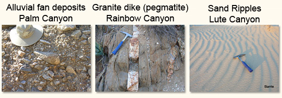
stage for other geologic processes, including erosion and deposition. As the
mountains rise, pushed upward along faults, wind, water and gravity wear
them down via erosion. The eroded material is in turn carried by streams
into down-faulted basins, where it accumulates in layers to become sediments
and sedimentary rock.
ANZA-BORREGO FOSSILS
In addition to its rocks and faults, Anza-Borrego is world-famous for its
fossils. Roughly 5 million years ago, as Baja tore away from mainland Mexico
along the evolving Pacific-North American plate boundary, a warm, tropical
sea flooded the region that is now Anza-Borrego. Known to paleontologists as
the Imperial Sea, this ancient water body hosted an abundance of life forms,
now preserved as fossils, including walruses, pelicans, sea turtles,
mussels, abalone, barnacles, snails, and more. Interestingly, this ancient
sea had a direct connection to the Caribbean, as evidenced by the many
marine species common to both regions.
By 3.5 million years ago, a land connection between North and South America
had been established, and the Imperial Sea had disappeared as the
Anza-Borrego region slid slowly northwestward along the Pacific-North
American plate boundary. A low-lying, flat topography developed as the
ancestral Colorado River migrated into the region, creating a variety of
habitats for diverse life forms, including elephant-like gomptherium,
horses, birds, ground sloths, rabbits, porcupines, bears, saber-tooth cats,
and camels, to name just a few of the many species found so far.
By about 1 million years ago, the landscape east of Borrego Springs had
become a combination of dry, brushy grassland, lake, and stream
environments. Mammoths, llamas, camels, squirrels, horses, and coyotes
frequented river banks and lake shores.
SUMMARY
From its beginnings almost half a billion years ago, the Anza-Borrego region
has experienced a rich and complex geologic history. Marine deposition along
the western edge of the ancient North American continent eventually gave way
to an extended period (over 100 million years!) of plate subduction, which
produced the vast volumes of granitic rock exposed in Anza-Borrego’s
mountain ranges and transformed older sedimentary rock into metamorphic
rock. Within the last 30 million years, a complex transform-divergent plate
boundary has developed within the region, creating towering mountain ranges,
deep basins, and thick deposits of fossil-bearing sedimentary rock. Ancient
seas, rivers, and lakes have come and gone, even as ancient life forms have
evolved, diversified, and gone extinct. And we are left in awe and amazement
at the wonder of it all. As Charles Darwin wrote, “There is grandeur in this
view of life…”
MORE TO EXPLORE
|
|
|

|