ANZA-BORREGO WEATHER

When most people think of Anza-Borrego weather they may think of Borrego Springs, where the temperatures are high, humidity is often low, and the sky is a clear deep blue. 

But Anza-Borrego weather is actually extremely varied, with as many variations taking place at one time as you might find across the entire state of California. 

Historical Weather Data - Check temps, rainfall, etc : A-B Desert Research Center

Two key factors influencing Anza-Borrego weather are elevation and exposure to the Pacific weather patterns that move across southern California.


As storms move across the mountains that surround Borrego Springs, the air is forced upward, where it cools, water condenses, and precipitation falls as rain or snow.  It very common to see snow on the mountain peaks in Borrego during the late fall, winter, and early spring.  Having dropped most of their moisture in the mountains these weather patterns are relatively dry by the time they blow over the lowlands of the desert, an effect that is known as a rain shadow.   Many of the large world's desert are created by this same effect.

Elevations in Anza-Borrego Desert State Park range from near sea level, in the eastern areas closest to the Salton Sea, to over 6200 feet in the mountains. 

Within Anza-Borrego, very slight differences in temperature and average annual rainfall have created countless life zones, where the plants and animals have adapted to the unique condition conditions found in that zone.  

Data from the National Weather Service, show just how different things can be in different parts of Anza-Borrego.  The town of Borrego Springs, elevation 597 feet is just 15 miles from the community of Ranchita, at an elevation of 4065 feet.

The town of Borrego Springs, elevation 597, is known for its sunny and warm winter weather.

 
Winter snow is common in the mountains around Borrego Springs. But it rarely gets much closer than shown in this photo.


These two locations in Anza-Borrego give a glimpse of the sharp differences in climate between high and low elevations.
 
Historical Weather Information For Borrego Springs - Elevation 597
Month Average High Average Low Average Precipitation Record High Record Low
Jan 69°F 44°F 1.14 in. 90°F /1971 20°F /1971
Feb 72°F 46°F 1.37 in. 95°F /1989 24°F /1990
Mar 78°F 49°F 0.84 in. 101°F /1989 23°F /1997
Apr 84°F 53°F 0.17 in. 111°F /1989 28°F /1972
May 93°F 60°F 0.05 in. 115°F /2003 34°F /1972
Jun 102°F 68°F 0.02 in. 122°F /1990 45°F /1971
Jul 107°F 75°F 0.30 in. 121°F /1995 56°F /1987
Aug 106°F 75°F 0.44 in. 120°F 1977 55°F /1973
Sep 100°F 69°F 0.31 in. 117°F 1990 49°F /1986
Oct 89°F 60°F 0.24 in. 113°F 1980 33°F /1971
Nov 77°F 49°F 0.39 in. 98°F /1988 32°F /2006
Dec 68°F 43°F 0.91 in. 87°F /1989 23°F /1990
   
Borrego Average 6.18 inches per year
Average monthly mean temp 72.7°


Historical Weather Information For Ranchita - Elevation 4056

Month

Average High Average Low Average Precipitation Record High Record Low
Jan 52°F 29°F 5.54 in. 74°F /2002 -4°F /1949
Feb 53°F 30°F 6.77 in. 75°F /1963 4°F /1990
Mar 56°F 32°F 5.77 in. 80°F /2007 10°F /1999
Apr 61°F 35°F 2.67 in. 85°F /1989 20°F /1999
May 69°F 40°F 0.71 in. 92°F /2003 22°F /1990
Jun 77°F 54°F 0.20 in. 98°F /1994 27°F /1965
Jul 85°F 54°F 0.41 in. 103°F /2007 34°F /1948
Aug 85°F 53°F 0.82 in. 110°F /1969 33°F /1948
Sep 80°F 47°F 0.74 in. 99°F /1948 23°F /1948
Oct 70°F 38°F 1.88 in. 93°F /1965 15°F /1961
Nov 60°F 32°F 3.26 in. 85°F /1963 10°F /1964
Dec 52°F 27°F 4.89 in. 75°F (1989) -1°F /1960
 
Ranchita Average 33.66 inches per year
Average Monthly Mean Temp: 52.9°
 

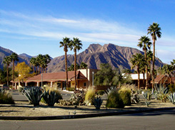
The Desert Monsoon Season and flash floods

Although desert flash floods can occur at any time of year the most common time in Anza-Borrego is during the late summer monsoon season (July - August - September). During the monsoon season the airflow changes from west to east to south to north and large masses of warm and very moist air come into the deserts of Arizona and Southern California from Mexico.  As each day gets started and the strong summer sun warms the ground, this moist air is heated and it rises higher into the atmosphere, where clouds form as the water condenses.


Powerful thunderstorms are then created that can drop large amounts of rain in a very short period of time, sometimes at a rate of several inches per hour.  The soil is unable to absorb the water at the rate it is falling so a widespread surface flow quickly develops across the land.  The surface flow may only be a fraction of an inch deep but across thousands of acres or many square miles, an enormous amount of water can rapidly be on the move.  All of this water heads for the lowest ground,  and the water continues to consolidate as it finds the path of least resistance headed downhill.  This does not need to be in steep terrain.  An area that may appear relatively flat can quickly accumulate a tremendous flow of water across an incline that may scarcely be visible.  The water may spread out for miles or, in places where it is confined to narrow canyons or dips in roadways, it can turn a dry area into a violent river of water capable of carrying trees and cars in as little as ten or fifteen minutes. 


The most significant floods occur when these thunderstorm systems become stationary.  A vertical "conveyer belt" effect is created in which hot air rises into the sky, cools and condenses, and drops heavy rain.  The air is reheated at ground level and then drawn up again and again to repeat the cycle.  The result is a powerful stationary weather system that becomes a very localized and relentless rain-making machine.  The record rate of rainfall in California during a one hour period is 10.1 inches, recorded in Campo, just a few miles north of the Mexican border in San Diego County, during one such event.  in 2013 the city of Mecca, Ca experienced over five inches of rain in a twenty minute period from one of these storms.


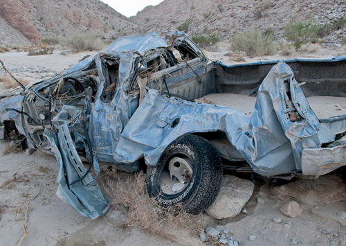
It has been said that the two most common ways for people to die in the desert are from thirst and by drowning.


The lack of vegetative cover in the desert allows the water to gather momentum and the washes or canyons where it accumulates can become raging torrents in a very short period of time. The land does not need to be steep for flash floods to occur, large gently sloping areas can also accumulate large amounts of water.


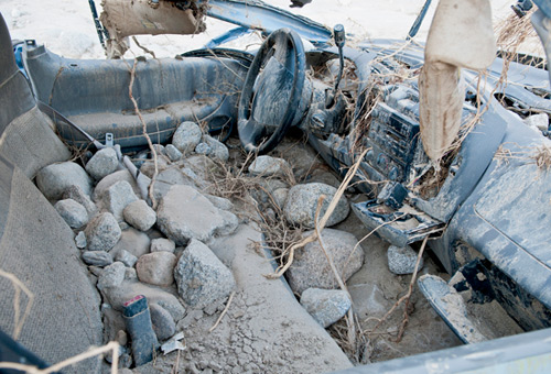
Desert flash floods can quickly cut through the earth, dislodging sand, rocks, boulders, and trees, and then deposit them many miles from their source.


Flash floods are particularly dangerous because it is very difficult to predict exactly when and where they may take place.  Forecasters may only know the general area where flashloods are likely, such as "The desert areas of southern Calfornia" but they cannot pinpoint where in that vast area that the localized weather systems to create the floods will be formed. 

Flash Flood Safety
These photos show what happened to a pickup in late July 2012 in the Fish Creek area when a flash flood struck. The owner of the pickup and his son went out to hike to the wind caves. When the water started flowing, there was no time to move the pickup, but dad and his son were able to make it to higher ground and were not harmed.   But the pickup was pushed well over a mile down the wash before it came to rest.  This is what was left of it.  --  Photos by Thomas Teske

The following are general flood safety rules that could help in keeping you out of danger:

  • Keep an eye on the weather. If the weather is questionable don't go into areas that are susceptible to flash flooding. The National Weather Service will often issue flash flood advisories for widespread areas. Floods can occur many miles from the rainfall so the only safe option is to stay out of areas that are prone to flooding, particularly remote areas.
  • If you are caught unaware, move to higher ground immediately.

  • If you are driving, never try to drive through a flash flood. The force of the water can be extreme. According to FEMA, many passenger cars will loose control and stall in just six inches of water. A foot of water will float many vehicles. Two feet of water will carry most vehicles away, including SUVs.

  • Never enter a flooded road or wash. The depth of the water can be deceiving as the roadway surface may not be where you think it is under the water.  The surface of the road my have been eroded and water you expect to be a few inches deep can easiliy be a few feet deep.


  • Flash floods are the number one cause of weather related deaths in the United States. The majority of people killed by flash floods in the United States are killed in vehicles that are swept away by the force of the water.


image


image


image